


LINCOLN – Town officials say they want to hear from residents about the Saylesville/Lonsdale Neighborhoods Complete Streets Study.
On Wednesday, Sept. 16, an in-person public workshop will be held at the Lincoln Senior Center, 150 Jenckes Hill Road, from 6 to 7:30 p.m.
The town is working to improve walking, biking, and transit access in the Lonsdale and Saylesville neighborhoods through a Complete Streets Study focused on making local streets safer and more connected for people of all ages and abilities.
Building on the town’s recently adopted Comprehensive Plan and Safety Action Plan, the study will also strengthen access to local businesses, historic mill redevelopment, and recreation destinations.
Wednesday’s workshop marks the first public engagement opportunity for the project, focused on reviewing existing conditions along key corridors and gathering community input before the project moves into its next phase: developing concept designs for priority streets and intersections.
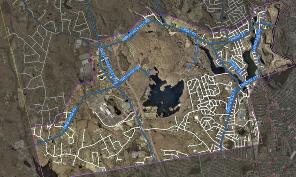
The study builds on the Town’s Safety Action Plan and Vision Zero resolution, which set a goal of eliminating traffic-related deaths and serious injuries in Lincoln by 2035. It will examine priority streets throughout Lonsdale and Saylesville, including Chapel Street, Walker Street, Smithfield Avenue, Front Street, Great Road along Route 123, and others identified through the Safety Action Plan, with particular attention to the intersection of Chapel and Walker streets, which the town has identified as prone to crashes and near-misses due to high vehicle speeds.
Planners are also considering several additional roads, including Cobble Hill Road, Parker Street, and Old Louisquisset Pike, to identify opportunities for safer crossings, new sidewalks, and improved bicycle facilities. The study will strengthen connections between residential neighborhoods and major destinations including Lincoln Woods State Park, the Blackstone River Greenway, Twin River Casino, the Community College of Rhode Island’s Lincoln campus, local schools, and village commercial centers such as the Saylesville Mill Complex and the Lincoln Shopping Center on Front Street, states a release.
Input gathered at the Sept. 16 workshop will directly shape the concept designs the project team develops in the coming months. Topics of discussion may include:
• Current conditions and safety challenges along neighborhood streets, including sidewalk quality, crossing safety, and speeding;
• Community priorities for future improvements, such as bike lanes, safer intersections, and better connections to schools, businesses, and recreation destinations;
• Opportunities to support economic vitality along key corridors like Front Street and Smithfield Avenue, and around the historic mill redevelopment near Chapel Street.
• How the study can build on the input residents have already shared through the Town’s Safety Action Plan process.
The public workshop on Sept. 16 will be run by the town’s Planning Department and its consultant team, Toole Design Group, with support from Foursquare ITP, in partnership with the Rhode Island Division of Statewide Planning. The meeting will include an overview of existing conditions in Lonsdale and Saylesville and a facilitated discussion to gather resident input. Beyond the scheduled public workshop, the Town will continue to engage residents throughout the project, including through the Lincoln Safe Streets Committee, stakeholder interviews, and regular project website updates, as the study advances toward a second public workshop, expected in early spring 2027, and, ultimately, a final report.
“This study is our chance to turn the concerns residents have already raised through our Safety Action Plan into real, actionable projects for Saylesville and Lonsdale,” says Town Planner Stephanie Davies. “We encourage everyone who lives, works, or travels through these neighborhoods to come share their perspective.”
This project is part of the Rhode Island Division of Statewide Planning’s Local Technical Assistance Program, which provides no-cost planning assistance to communities in support of “Moving Forward RI 2050,” the State’s Long-Range Transportation Plan.
For additional information about the upcoming public workshop and the project, contact Stephanie Davies, Town Planner, at .
In January, the Division of Statewide Planning kicked off new local technical assistance planning project with the town of Lincoln focused on conceptual redesign of specific corridors within the neighborhoods of Saylesville and Lonsdale.