




Note: This story will continue to be updated throughout the weekend with storm updates. Send us photos to .
Sept. 26 – 8 p.m.
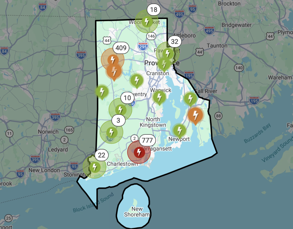
A total of 6,057 people statewide are without power around 8 p.m., including a new cluster of outages in the Great Road area of Lincoln. Some 2,000 customers in the Cumberland Hill area of northern Cumberland were looking at a 6 a.m. restoration time for power to come back on after a pair of blown transformers, but the lights are now back on for most.
Block Island has now seen more than 24 hours of tropical storm conditions, with current sustained winds at 48 mph.
Sept. 26 – 2:40 p.m.
Some models are calling for 6 or more inches of rain to still fall by Monday, meaning what’s transpired to this point might be considered the calm before the storm.
A flood watch is in effect through late Monday night for central and eastern Massachusetts as well as all of Rhode Island, with excessive rain possible. Runoff may result in flooding of rivers, creeks, streams, and other low-lying and flood-prone locations, according to the National Weather Service. Creeks and streams may rise out of their banks.
General totals of 2-4 inches of rain will be widespread, but localized amounts of 5-7 inches are possible. If these higher amounts are realized, the potential for both urban and small river/stream flooding would increase. This is particularly true if these localized higher amounts occur over a vulnerable urban center.
Sept. 26 – 11:35 a.m.
As of late morning, Rhode Island Energy is reporting 1,443 customers without power statewide, up about 300 from 30 minutes ago but down about 10,000 from early this morning. Most have been toward the southern end of the state. That number is expected to go up as the storm gets closer and intensifies later in the day. Rain will also pick up, but there will be lulls.
Residents across the northern Rhode Island area are reporting trees down, but most seem to be in yards and away from power lines.
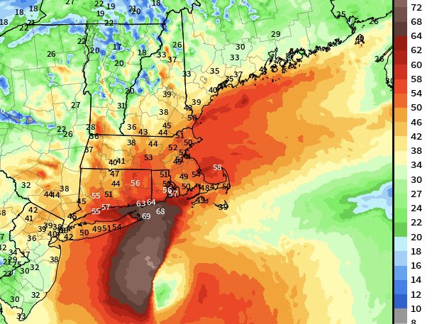
According to the latest guidance on the storm, the strongest winds for inland areas will be this evening and overnight. Some models are showing it getting slightly closer before turning west, which would cause more issues.
The strongest recorded gust for Rhode Island so far has been 71.4 mph on Block Island, where a utility pole snapped. Gusts inland are expected o top out around 55 mph. The National Weather Service’s wind advisory is still predicting maximum gusts of 45 mph.
Rainfall totals are still expected to be in the range of 2 to 4 inches, with locally higher amounts possible.
Sept. 25 – 11 p.m.



Sept. 25 – 5:05 p.m.
Winds are picking up on Block Island, where they’ve hit sustained 36 mph and gusts to 45 mph.
Sept. 25 – 4:50 p.m.
Wright’s Dairy with the classic post.
Sept. 25 – 2:30 p.m.
Ahead of this weekend’s storm, says the Rhode Island Department of Transportation, they’ve been out this week inspecting roadways and cleaning catch basins, as well as readying vehicles and portable equipment.
“We’re closely monitoring the forecast and will be ready to call in crews as needed throughout the weekend to address any issues with street flooding or downed limbs or trees,” said the agency. “Avoid any unnecessary travel and never drive through a flooded roadway. Stay safe.”
Sept. 25 – 2 p.m.
We’re starting to see a few dead branches down, but nothing significant as of yet.
Sept. 25 – noon
If you haven’t already, make sure to tie down your trampoline. I learned my lesson from the last two storms.

Sept. 24 – 11 p.m.
Incoming Nor’easter tracking west and slightly more impactful
Forecasters say the incoming Nor’easter is tracking slightly west and moving more slowly, meaning a somewhat more impactful storm than previously expected.
The GFS model, which has been all over the place the last few days, has now come in line with the Euro, showing a stall and loop somewhere south of Long Island. That means an extended rain and wind event for southern New England, New Jersey, Long Island, New York City, and Connecticut.
Rain totaling 2-4 inches will extend over much of the area, with locally higher amounts possible.
Sign up for The Local Insider newsletter.
Many activities, including youth soccer and other sports, have already been canceled.
A wind advisory is in effect from 8 a.m. Friday to 2 a.m. Sunday, with northeast winds between 15 and 25 mph and gusts up to 50 mph expected for northwest Providence County.
Stronger winds are expected further south, and will be particularly impactful at the shore, where there will be minor coastal flooding.
Showers will form Friday evening, with periods of rain and wind heaviest on Saturday. Expect both banding and lulls. The storm will slowly wind down on Sunday, with some wet weather into Monday.
Because of the duration of the event, the risk of serious flooding is low.
Gusty winds will blow around unsecured objects, according to the National Weather Service. Tree limbs could be blown down and a few power outages may result.
The long duration of the winds coupled with heavy rain and fully leafed trees may exacerbate the risk for tree damage and power outages.
Winds this strong can make driving difficult, especially for high profile vehicles. Use extra caution, says the NWS.
Rhode Island Energy is reminding everyone to stay away from downed wires, assuming that they are energized. Never drive over one, and if you see one, call 855-743-1101 or 911.
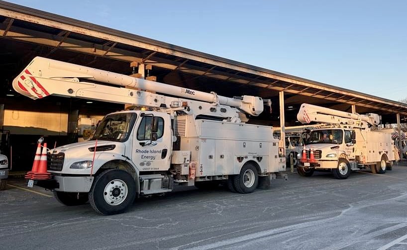
The primary concerns associated with this storm include potentially hazardous wind gusts along with steady rainfall that could cause flooding in low lying areas, according to Rhode Island Energy. Elevated wind gusts can damage trees and bring down power lines, causing outages in affected areas. Inclement weather is forecasted through Sunday evening, with calmer weather anticipated on Monday.
“We have been tracking this storm for several days and have secured additional crews and personnel who stand ready to respond to any impacts the weather may bring,” said Joe Curley, vice president of electric operations at Rhode Island Energy. “In the event of outages, our crews and support teams will be working around the clock to restore service as quickly and safely as conditions allow.”
As part of the company’s emergency response operations and preparedness activities, RIE has mobilized additional resources. This includes overhead and underground line workers for distribution and transmission restoration, tree-trimming crews, wires-down personnel, and substation workers. As forecasts evolve, the company will continue to assess resource needs and communicate with local officials, first responders, and life support customers.